
A POSSIBLE ROMAN ROAD CUTTING AT INNERPEFFRAY LIBRARY PERTSHIRE
D.J.Woolliscroft, with a contribution by B.Hoffmann.
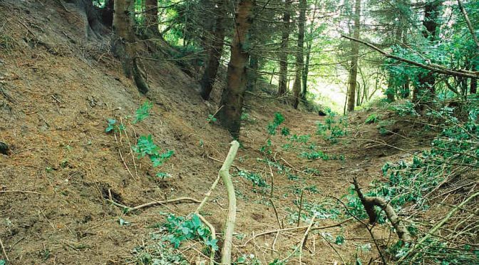
Archaeologists have long been aware of a superbly preserved and obviously artificial cutting running through woodland, immediately S of Innerpeffray Library (Fig 1 & Fig 2), on the E side of the River Earn (NGR NN902184). 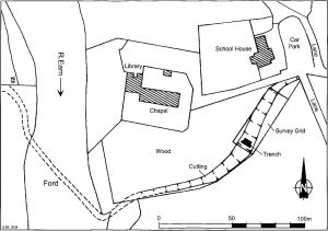 The library stands on an eroded drumlin atop an almost sheer river cliff and local lore has it that the cutting represents the Roman Gask road coming up the otherwise very steep bank from its crossing of the Earn. This has always seemed eminently plausible, especially in view of the scale of engineering involved. The top (E end) of the feature can be seen turning onto an alignment which heads towards the next known stretch of the Roman road, in and around Parkneuk Wood (NGR NN912184 – 917185) (Woolliscroft and Davies, 2002). Its lower end is aligned on an old ford in the river, from the opposite end of which air photography has detected what seems to be the road to the Roman fort of Strageath, which lies just 350m to the SW. Indeed, some scholars appear to have accepted the identification without comment (eg Frere & Wilkes, 1989, fig 4). Nevertheless, no archaeological work had been undertaken on the feature to seek proof either way. In June 2004, therefore, the Roman Gask Project undertook a survey and trial excavation, funded by the Perth & Kinross Heritage Trust.
 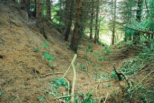 The work was directed by the writer, assisted by Ms I.Hallyburton and by Mr D.Hodgson, who supervised the survey. The site was crewed by volunteers as part of Perth Archaeology Week.
The Survey
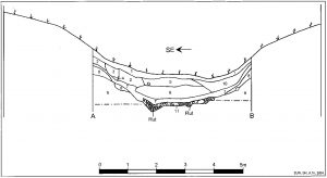
The cutting survives as a surface feature, 12-15m wide and over 130m long. Much of it lies in dense thicket, but it did prove possible to conduct a levelling survey of a 15m x 42m sample in the time available, with spot heights taken in a grid pattern at 0.5m intervals. 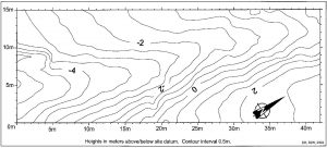 The results (Fig 3) show that the feature survives at depths of up to 3.5m and, at least at the modern surface, its bottom ascends the otherwise very steep slope at a fairly even gradient of 7.7o (1:5.7), which should have been gentle enough to allow the passage of wheeled traffic. The average depth of the surface feature over its entire length was c. 1.5m, although the original average is likely to have been rather greater (see below).
The Excavation
A 5.5m x 1m section (Fig 4) was excavated across the cutting bottom, near the SW end of the survey grid (Fig 1) and later extended to the NE. This revealed a well preserved metalled road surface (Fig 6, plus Fig 4 & Fig 5, Layer 11) averaging 2.8m (9′ 2″) wide and consisting of stones up to 0.3m across, set in a matrix of dirty pinky clay and gravel, up to 0.28m thick.
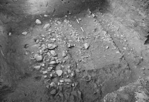 This surface was badly worn and marked by a pair of clear wheel ruts with an average centre line separation of 1.57m (5′ 2″). There were few signs of repair, although river gravel had been added to partly fill the ruts at some point. Instead, there were signs that an original surface had been worn away and that the road’s final traffic was actually running on the substructure. For a band of significantly larger stones was revealed along the road’s eastern edge, the part least affected by the ruts. This lay on top of the clay and gravel matrix and might represent part of an original paving layer.
 No signs of side drains were uncovered and the road bed was fairly waterproof. As it survives, the surface is slightly concave and the cutting’s angle of slope is such that the road itself would rapidly channel rain water down to the river. The original surface may well have been flat, or more probably convex, but it would still have shed water fairly readily. A single fragment of Medieval green glazed pottery was found on the northern roadside and a small piece of 18th-century white glazed pot was found in the southern wheel rut. No datable carbon was present in the road structure and no deposits likely to contain pollen or other organic data were uncovered.
On both sides of the road the clay and gravel matrix blended into a cleaner, stone free layer of waterproof and apparently puddled pink clay which extended up the cutting sides for at least the full extent of the excavation trench. This had been broken up to some degree by tree roots, especially in the area of the drawn section (Fig 4, L’ 8), but it may originally have been designed as a revetment for the steep cutting sides. These were, after all, cut through pure and relatively loose glacial sand (Fig 4, L’ 9) which would otherwise have been extremely vulnerable to weathering and collapse. A 1m wide strip against the drawn section was excavated down to the natural sand, but no features were found underlying the road.
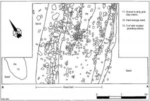
On its abandonment, the road surface and cutting sides were covered by a layer of sandy soil (Fig 4, L’ 7) up to 0.24m thick. Through this a pit had been cut (Fig 6, L’ 12) which also penetrated the road surface. This was 0.48m wide and at least 1.15m long, but extended beyond the confines of the trench. It was filled by a hard, compacted orange sand and contained no datable material.
The post-road topsoil was overlain by a deep overburden of fairly modern deposits, much of which seemed to have been deliberately dumped down the cutting side from the SE. The first (Fig 4, L’ 6) was a 0.4m thick layer of clean orange sand which contained a modern nail, a barbed wire fragment and a deflated rubber tennis ball. This was overlain by two layers both c. 0.32m thick. The first (Fig 4, L’ 2) was a rather less pure sand layer and the second, which seemed to be slightly later, appeared to be dumped topsoil (Fig 4, L’ 5) containing fragments of plant pot and Victorian china. These were themselves overlain by a layer of sandy loam, up to 0.37m thick (Fig 4, L’ 10) which appeared to have washed in from the opposite (NW) side of the cutting. Layers 2 and 10 had then themselves been cut by two pits. That cut into L’2 was 0.45m wide and 0.41m deep (Fig 4, L’s 3 & 4) and contained no datable material. The pit through L’ 10 penetrated c. 1m down to beyond the level of the road surface, although it lay slightly to its NW (Fig 6, L’ 13), and contained a mixture of turf and relatively modern plumbing debris, including pieces of enamelled iron pipe and an old high level lavatory cistern. Finally, the deposits had been covered by a thin woodland topsoil, just 0.16m thick and consisting mostly of leaf mould (Fig 4, L’ 1). In all, the road surface lay between 0.65 and 1.06m below the modern surface, with an average depth of around 1m.
Discussion
The traditional assumption that the Innerpeffray cutting represents the Roman Gask road has been at least partly vindicated: for the feature is definitely a road. Whether it is Roman is less certain, however. Certainly, no datable Roman material was uncovered, but then this is often the case with Roman roads, especially on small excavations. There are, however, a number of factors which might make a Roman origin seem likely. The first is the fact that the cutting falls in so readily with the known course of the Roman road through the area. The second is the sheer scale of the engineering involved, coupled to the dating evidence that was recovered. Given the depth of overburden above the road surface, the 3.5m maximum depth of the surface feature becomes an original cutting of around 4.5m maximum depth and the 1.5m average depth might be increased to at least 2m. Given a 2.8m wide road bed and a 12m cutting top, this would mean that a minimum average of 14.8m3 of material has been removed for each 1m of road, a total of at least 1920m3, or well over 2,000 tons. The resulting steep-sided cutting was then revetted well enough that it has survived as a clear cut surface feature despite being run through what is essentially a large natural sand pile, and a durable road surface was laid with a very even gradient. At the same time, the presence of Medieval pottery and the wear evidence for very prolonged use, would suggest that it was built before the 18th-century, albeit there is pottery evidence for use up to at least that time. With the exception of bridge building, however, the Medieval period is not noted for sophisticated road engineering. Indeed, virtually the only properly engineered rural roads in Scotland before the 18th-century were Roman.
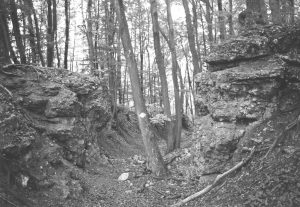
One counter argument might be that the cutting’s 2.8m wide road bed is markedly narrower than any of the known Gask road stretches: which range from 5.79m to 7.92m (19′ – 26′) in width (Woolliscroft & Davies 2002, 56). Interestingly, however, there are quite a number of parallels for similar cuttings that are known to be Roman and where a similar narrowing of the road has been found. What are probably the best known examples have been found in and around the Alpine passes in Switzerland, where cuttings are known ia through the Great St Bernard Pass and, on the Jura, at Effingen/Unterbözberg (Fig 7), Langenbruck, Bivio and Stampa/Maloja (Drack & Fellmann 1988, 367, 373, 390, 419 & 550). These are often broadly similar in width, with the Great St Bernard cutting almost identical at 2.7m. Some are also noticeably steeper, with the Stampa/Maloja cutting reaching a slope of 30%. Yet all seem to have been used by wheeled traffic as, again, wheel ruts are often found, albeit with narrower axle gauges of between 1.07m and 1.3m. In all cases, the narrowing of the road is presumably a labour saving measure to allow heavy traffic to move up and down a more gentle gradient, albeit only in one direction at a time, without the need to excavate the full width of a two carriageway road. If so, the saving would have been considerable. For example, had the Innerpeffray cutting been dug to the full average width of the Gask road (c. 6.8m), an additional c. 1050m3 of earth would have needed to be moved, a 54% increase in an already considerable workload and so the design represents a good compromise between economy of construction and user convenience. This cannot be regarded as conclusive, and it is to be hoped that the site will be investigated further, but the current evidence is probably enough to at least incline the balance of probability towards a Roman date. What is undeniable, however, is that the cutting represents a most impressive ancient monument and it is to be hoped that nothing will be done in the future to endanger its survival.
Archival evidence for the abandonment of the Innerpeffray road cutting
by Birgitta Hoffmann.
The Innerpeffray Library excavation was able to confirm the presence of a well engineered road cutting, but did not provide conclusive dating evidence. The best parallels are Roman, but the road’s importance in the Medieval period is suggested by the presence of Innerpeffray library and chapel close by. The fact that the chapel formed part of Muthill parish (which is otherwise located on the opposite site of the Earn), suggests that easy access from the other side of the river was available at the time of its construction, which may provide a tentative terminus ante quem for the road. Could the cutting thus be part of a Medieval scheme? Medieval road building tends to receive less attention than Roman or early Modern parallels, perhaps because of the less impressive nature of the surviving remains. Advanced engineering tended to be restricted to bridge building, although the skills needed for more complex construction elsewhere were available when needed, as is shown by the Medieval works in the St. Gotthard pass (Meyers Konversationlexikon, 1887, vol 14, 286). The best quality roads of the period, especially in Britain, were usually associated with religious demands, be they pilgrims’ ways, more local tracks to parish churches or roads used in the administration of monastic estates. Even then, however, they were normally little more than tracks, with few signs of the engineering skills and effort displayed in the Innerpeffray cutting (Hindle 1998).
In Scotland, evidence for Medieval road building (as opposed to maintenance) is scarce. James Macdonald (1893) was only able to cite the following examples of roads newly constructed before the 18th-century: In 1250 John Comyn granted Melrose (Abbey) ‘free passage through the middle of his lands of Dalswinton to their lands at Nithsdale’ and continued ‘if the aforementioned road, through inundations or its being long used for wagons, gets out of repair, the monks and their dependants shall have full liberty to renew the same road by ditches and causeways, or in any other way they please’ (liber de Melros VI 1.1 no. 319 cited by Macdonald 1893, 43). For 1582 Macdonald (1893, 43) cited evidence from Ayr, which ordered ‘a hie street and passage to me amid from Langshot Moss to Threipland Dyke, of the breid of sex fallis’. There are further references to the existence of ‘king’s high roads’ (Macdonald 1893, 45), but it is unclear whether these were newly constructed or used pre-existing tracks. These were not the whole story, as can be shown by the evidence from Atholl, where Wade’s Road was preceded by two engineered pre 18th-century roads. These were the Minigaig (perhaps already marked in Moll’s 1725 map) and the even earlier Comyn’s (Rathan nan Cuimeinach) or Wine road (Rad na-Pheny), which is described as paved and suitable for wagons in some sources. Both appear to have linked Blair Atholl and Ruthven/Kingussie. The older road cannot be ascribed any historical date and its association with the Comyns apparently owes more to folklore than to historical proof. It is thus hardly surprising that, despite its location, there are occasional rumours of a Roman date (Keillar 2001). But the reoccurrence of the Comyns, who we have already seen supporting road building in the South, is suggestive, so a Medieval date for the Wine road should not be ruled out.
The situation at Innerpeffray is very different, however. Major engineering was mostly the work of powerful landowners, such as monasteries and, particularly, the Cistercians whose skills are well attested. The church on the Gask came under the Bishop of Dunkeld, but although there were a number of smaller monastic houses in the area, the nearest abbey with the necessary skills and resources would have been the Cistercians at Coupar Angus. A review of the latter’s records did produce references to the de Innerpeffrays (Charters of Coupar Angus Abbey I, 185-7 and 210-214: dated 1306-20), but failed to yield evidence for sufficiently large holdings or other interests in the area to justify major investment. This is admittedly circumstantial, based on an absence of evidence, but it might support the view that a period other than (and thus before) the Middle Ages was responsible for the road’s construction and this really leaves only the Romans.
Rather more can be said about the cutting’s likely later history. The early modern period brought increased traffic to this part of Strathearn. In 1672 an Act of Parliament granted the Earl of Perth the right to establish a large cattle market at Crieff (Haldane 1952, 134). This was held in mid October and quickly became the chief cattle tryst of Scotland, with reports of 30,000 head changing hands during the fair, mostly to be exported south. While the majority of the cattle were probably brought in via the Sma’ Glen and the glens further west, cattle from Angus and Aberdeenshire tended to be driven from Perth via the ‘Old Gallows Road’. Described in 1715/6 as ‘the road to Stirling’ (Tabraham and Grove 1995, pl. 4), this leads out of Perth past Long Causeway, Burghmuir Road, the Old Gallows Road at Glendevon Farm, and continues today as a line of hedgerows, field tracks and short roads past the old farms of Gateside, East and West Cultmalundie, Westmuir, Clathymore, Clathy, Roundlaw, Ardunie and Shearerston. It eventually crossed the Earn at Innerpeffray, with further branches leading to Crieff and Kinkell. As the name suggests, it appears to have run past the Gallows to the west of Perth, whilst the early 19th century ‘Notes of the Statute Labour Trustees’ already describe it as old and confirm its use as a drove road.
A second important road from Innerpeffray to Perth ran just to the south. This was ‘The ‘Roman Road’ or ‘Street Road’ and followed the course of the Roman Gask frontier road past the 1st-century watchtowers on the Gask Ridge, before turning north near Windygates to reach the Old Gallows Road somewhere between Tibbermore and West Lamberkine. To judge from 18th century maps, such as Moll’s of 1745 and Stobie’s of 1783, both roads were in use side by side, but the ‘Street Road’ appears to have degenerated into a track to the east of Gask House, suggesting that it may have been of mere local importance, a fact born out by the statement in the Old Statistical Account (vol 1, 481 and Vol. 18, 486) for the parishes of Gask and Trinity Gask, that it saw little use, despite being still in a good state.
The 18th-century saw large road building projects in Scotland, with associated improvements to the wider infrastructure. The first impact on the use of the Innerpeffray cutting must have been felt with the construction of Crieff bridge in 1741-2, as part of the road from Stirling to Inverness (Taylor 1996, 53). Designed to carry artillery, it was also able to take carriages over the Earn and thus provided a more comfortable route than the ford and steep incline at Innerpeffray, which may thus have seen a drop in use. The period after 1745 also saw the rapid decline of the Crieff cattle tryst, which was increasingly supplanted by Falkirk. Indeed, by the 1790s the cattle fair had become just a memory among the older residents of the town (OSA vol. 9, 596). Innerpeffray, being the principal ford along the Old Gallows road, may then have seen a brief increase in traffic, as it reduced travel times to Falkirk, but the need to cut journey times still shorter was already working against it. Maitland (1757, 198) described the Roman road from Strageath fort as ‘descending the eminence and, crossing the river Earn, mounting the hill to the village of Innerpeffray, in the neighbourhood of which it became the common road’. The fact that he was able to cross and that the route still appears on Stobie’s map of 1783, suggests that the ford and cutting were still usable at this time. But his statement that the common road did not begin until he reached the village might imply that they were no longer a major crossing point. If so, this would fit well with Moll’s map, produced a decade earlier in 1745. This still marks the Old Gallows Road, but shows Kinkell, not Innerpeffray, as the Earn crossing point. Kinkell was originally a ferry crossing (OSA vol 18, 486), but in 1793 this was replaced by a toll free bridge (NSA Vol. X, 381). This cut travel times and drovers’ costs still further and rapidly made its impact felt.
Further problems were to come which effected the rest of the Roman road on the Gask Ridge. Perth archive holds the ‘General Notes of Perth District Statute Labour Trustees’ (hereinafter PDSLT), which detail a number of road building projects in the area in the first half of the 19th century. From these it appears that the Old Gallows Road and the ‘Street’ or ‘Roman Road’ were maintained by the landowners on an equal footing up to 1813 (PDSLT Notes of 10 May 1803). However, with the continued development of turnpikes in the area, which included the roads from Perth to Crieff (OSA Vol. 17, 649f) and to the south, the drove road became a problem. The committee notes of 4th May 1813 record that it was decided to close the ‘Old Gallows Road’ and a series of connecting branch roads, on application by the Lord of Kinnoull and Robert Smyth of Methven. The reasoning was as follows: ‘…the road called Gallows road is of little or no use, but is the cause of much evasion from the adjoining turnpike roads as people using the turnpike are easily enabled by means of said road to gain the Town {i.e. Perth} without passing any of the bars either on the Crieff or Dalreoch roads and in particular droves of cattle and sheep always take that road in crossing the Country to Falkirk and the west, and it can be well established that numbers people residing on the south of the Dalreoch road and the on the north of the Crieff road, are in the habit after using in part both these roads to come into Perth by the Gallows road. It is equally true that the persons residing nearer the town and whose properties adjoining the road have good accesses and of equally short distance by the said turnpike roads…’ (PDSLT 4 May 1813). In other words the Committee was attempting to stop travellers evading the turnpike tolls and, while their report for the following year notes that the road could not be shut up completely as it provided access to some properties (PDSLT 3 May 1814), they intended to take steps to limit its use to local traffic only. Innerpeffray was not specifically mentioned in any of these exchanges, but it is likely that it was affected by these restrictions, which seem to have taken effect quite quickly. The 1823 edition of Stobie’s map (copy held in Perth Archives) shows the Old Gallows Road to have vanished completely between Ardunie and Cultmalundie, although the ‘Roman Road’ was shown as a continuous line between Innerpeffray and Windyedge (near Cultmalundie Wood). Five branch roads now linked this road with Kinkell Bridge, while the branch road to Crieff (the modern B8063) continued in operation. The Plan of the Perth Statute Labour roads surveyed by W. Archer in 1828 (held in Perth archive), shows the Old Gallows Road as a dotted line (indicating that it was not surveyed) between Clathy and Hill of Ruthven, while the ‘Roman Road’ is marked as a statute labour road leading not to Innerpeffray but to Kinkell Bridge. The latter description is repeated in the 1836 notes, where the road was described as running “from the Parks of Dupplin to Kinkell Bridge” (PDSLT 3 May 1836). By then, however, the state of even this road was apparently abysmal: ‘Considerable anxiety has been expressed for the repair of the Roman Road leading from Kinkell Bridge towards Perth – those lengths which render the line almost impassable in bad weather lie in the Parishes of Gask and Tibbermore and are in extent 2 miles 178 roods. The expense of complete repair would in including {sic} £70 for the cartage of materials be £340.’ And despite repairs made through donations in 1837 (PDSLT 3 May 1837) and a grant from the Trustees of £89 4/- 2 1/2d in 1838 (PDSLT 3 May 1838), by 1840 the road was again in a bad way, with the report reading as follows: ‘The Roman or Street Road is perhaps more difficult to preserve in proper repair than any other line in the district. It passes through woods for almost its whole extent, and the effects of the sun and wind are hardly perceptible. It is besides formed of metal of a very inferior quality, which is easily worn when in a wet or damp state. I have, however, opened two quarries of whinstone metal along the sides of the line, and the repair of last season, was generally effected by this material, and by the constant application of this stone, the surface will ultimately become hard and be less subject to be broken up. A perfect winter road cannot be promised here for two years to come’. (PDSLT 14 Feb 1840). By 1842 the Trustees were happy to report: ‘The Roman or Street Road has had much attention paid to it during the past three years and I am glad to find that it is now beginning to show the good effects of employing the best whinstone metal in its repair for although occasionally tracked in soft weather it never breaks in the manner in which it used to.’ (PDSLT 3 May 1842). The excavation found that none of this whinstone had been employed on the Innerpeffray cutting, despite deep rutting and other serious signs of wear, which suggests that it was no longer being maintained by this time. This adds further strength to the view that the ford lost much of it importance with the successful redirection of traffic such as large cattle drives to the bridges at Crieff and Kinkell. It was, however, still marked on J.Knox’s map of 1850 and so may have retained some purely local significance. By 1844 even more traffic was removed from the surviving parts of the Old Gallows road with the traffic around Clathy (to the north of Muir o’ Fauld and Gask House) being directed to the road past Findo Gask Church and onto the Roman Road towards Kinkell Bridge (PDSLT 7 May 1844). This would have further reduced the possible traffic through the ford at Innerpeffray, which would now only have interested people trying to get just across the river from Strageath to Shearerston or Innerpeffray and, a few years later, the first edition O.S. map shows the cutting as obstructed and included within a field.
If the surviving literary sources are of little help in determining the origins of the Innerpeffray cutting, they do help us to understand its use and decline as an active route and drove road following the construction of the 1742 road between Ardoch and Perth. Over the next 100 years the crossing was increasingly sidelined, not least by an effort to force more traffic onto turnpikes and thus raise revenues for their trusts. The building of the pontage-free Kinkell bridge in 1793 and the continued upgrading of the track of the ‘Roman road’ between Kinkell Bridge and Perth, as well as the progressive closure of the old drove road between 1813 and 1854, turned the old road cutting (and associated sections of the ‘Roman road’ and ‘Old Gallows Road’) more and more into an obsolete dead end, leading to its eventual abandonment by the 1860s.
Acknowledgements
The writer is grateful to the landowner Mr C.R. Connell for allowing access to the site, to Innerpeffray Library for car parking and toilet facilities and to the Perth & Kinross Heritage Trust for funding the work. Dr B.Hoffmann very kindly provided the photograph of the Effingen/Unterbözberg cutting reproduced as Fig 7 and I would particularly thank the volunteers who worked on the site, often in heavy rain. Dr Hoffmann is grateful to the staff of the Perth Archive for their unstinting assistance during the research for her piece.
References
Drack, W & Fellmann, R 1988 Die Römer in der Schweiz, Stuttgart.
Easson, D E (ed) 1947 Charters of the Abbey of Coupar Angus, Edinburgh.
Frere, S S & Wilkes, J J 1989 Strageath, Excavations Within the Roman Fort 1973-86, London (Britannia Monograph Series, 9).
Haldane, A R P 1952 The drove roads of Scotland. London.
Hindle, P 1998 Medieval roads and Tracks, Third edition, Prince Risborough.
Keillar, I 2001 ‘Comyn’s Road’ Moray Field Club Bulletin 29. 27-32.
Macdonald, J 1893 ‘Notes on the “Roman Roads” of the One-Inch Ordnance map of Scotland’, Proc Soc Antiq Scot, 28, 21-57.
Maitland, W 1757 The History and Antiquities of Scotland, Edinburgh.
Tabraham, C and Grove, D 1995 Fortress Scotland and the Jacobites, Edinburgh.
Taylor, W 1996 The Military Roads in Scotland, Isle of Colonsay.
Woolliscroft, D J 2002 The Roman Frontier on the Gask Ridge, Perth & Kinross, Oxford, (=BAR (British Series, 335).
Woolliscroft, D J & Davies, M H 2002 “Parkneuk Wood Roman Road, Perthshire: Excavations in 1967 and 1997” in Woolliscroft, D J 2002 The Roman Frontier on the Gask Ridge, Perth & Kinross, Oxford, (=BAR (British Series), 335, 52-61).
Archive maps used
Knox, J 1850 Map of the Basin of the Tay of 1850, http://www.nls.uk/digitallibrary/map Shelfmark: EMS.b.2.141.
Moll, H 1745: The South Part of Perthshire Containing Perth, Strathern, Stormount and Cars of Gourie, http://www.nls.uk/digitallibrary/map Shelfmark:EMS.b.2.1(21)
Stobie, J 1783 The counties of Perth and Clackmannan http://www.nls.uk/digitallibrary/map
Shelfmark: EMS.b.2.30),
Stobie, J 1823 The Counties of Perth and Clackmannan, Perth Archives.