

Iron Age and Roman Period native sites at East Coldoch, Stirling. An Interim Report for Work up to 2002.
All the illustrations to this report are available on one page here.
D.J.Woolliscroft and B. Hoffmann
The Site
East Coldoch (NMRS NS79NW34 & 35) lies approximately 900m to the northeast of Coldoch Broch on (despite its name) the farm of Mains of Burnbank ( Fig 1 ).
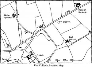
It was discovered from the air by the RCAHMS (Maxwell 1983, 48ff), as a penannular ring ditch, approximately 30m in external diameter. It is located on plough land and nothing is now visible on the surface, but air photographs show a slightly ovoid form, somewhat narrower from east-west than from north-south and with a single entrance break oriented towards the ENE. The feature had been damaged by the insertion of a modern water tank, but it was still possible to detect signs of a narrow slot, just inside the ditch, along with a dark central area which seemed likely to represent an internal structure. The site lies at NS 703986 on the summit of a low hill which, although only 41m high, offers a superb vantage point, with long range views in all directions, especially to the east and south, over the Forth valley and the hills beyond. Stirling Castle is in full view, at a range of 10 km to the ESE, as are the once strategically important Kippen road and Fords of Frew whilst, to the south, Leckie Broch is visible on the opposite side of the Forth basin. The site itself is relatively flat, but there is an abrupt break of slope about 25m to its south beyond which the ground drops steeply towards the Forth flood plain. The latter was moss land until drained in the improvement period and so the site would originally have been the first firm ground on the North side.
It was discovered from the air by the RCAHMS (Maxwell 1983, 48ff), as a penannular ring ditch, approximately 30m in external diameter. It is located on plough land and nothing is now visible on the surface, but air photographs show a slightly ovoid form, somewhat narrower from east-west than from north-south and with a single entrance break oriented towards the ENE. The feature had been damaged by the insertion of a modern water tank, but it was still possible to detect signs of a narrow slot, just inside the ditch, along with a dark central area which seemed likely to represent an internal structure. The site lies at NS 703986 on the summit of a low hill which, although only 41m high, offers a superb vantage point, with long range views in all directions, especially to the east and south, over the Forth valley and the hills beyond. Stirling Castle is in full view, at a range of 10 km to the ESE, as are the once strategically important Kippen road and Fords of Frew whilst, to the south, Leckie Broch is visible on the opposite side of the Forth basin. The site itself is relatively flat, but there is an abrupt break of slope about 25m to its south beyond which the ground drops steeply towards the Forth flood plain. The latter was moss land until drained in the improvement period and so the site would originally have been the first firm ground north of the river.
Copyright D.J.Woolliscroft
There are no streams in the immediate vicinity and the nearest spring is several hundred metres away, but the water table lies barely more than 1m below the surface. The subsoils are a mix of glacial deposits, varying from coarse sand and gravel, to clay, with plentiful sandstone fragments.
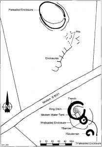
The writers originally became interested in the site during a search for possible Roman watch towers to the south of the known Gask series, and especially between Stirling and Doune, where they might help to trace the lost Roman road through the area. Air photographs showed the main ring ditch ( Fig 2 , Feature “A”) to be sitting amongst a palimpsest of lighter ditched structures, all of types that are usually regarded as Iron Age or late Bronze Age in date, but its morphology and much heavier ditch made it stand out in marked contrast to its neighbors. When coupled to its vantage point, this initially raised the possibility of a Roman military installation superimposed on a group of native structures, albeit its 30m diameter seemed unusually large for a Roman tower.
The complex of sites is now divided by the B8031, which tends to give the impression of two distinct settlements (indeed it is now scheduled as such). But although this is probably illusory, it will be convenient to deal with the two areas separately below.
Site 1 lies to the south of the modern road and contains the main Feature “A” ring ditch, which occupies a low mound that makes up the site’s highest point. To the south of this, air photographs show a much smaller (c. 11m diameter) ring ditch, containing a central dot, which seemed likely to represent a barrow ( Fig 2 , Feature “C”). There were also two faint, but much larger, partial rings (Features “B” & “D”) which intersected both each other, and Features “A” and “C” and appeared to be palisaded enclosures, whilst a single air photograph (CUCAP: CKO37) showed a crescent shaped crop mark (“E”) in the southern part of the site, whose form resembled a souterrain. To the north of the road, Site 2 consists of another large palisaded enclosure which shows signs of at least three concentric structural periods. This lies on a second low mound and makes up the site’s northernmost feature. Between it and the road the cropmarks of a number of pits are visible, which may or may not represent posthole structures, whilst a series of sub-rectangular enclosures could be fields, or even linked square barrows.
The Geophysical Surveys
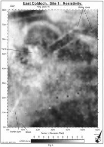
In 1996 a small (40m)2 resistivity survey of ring ditch “A” was undertaken to allow the accurate location of a small test trench (Woolliscroft & Lockett 2002, 48f). This was followed by larger scale work in 2000 to take in the whole of Sites 1 and 2. The final survey of Site 1 ( Fig 3 ) was 60m (e-w) x 80m (n-s). Little of archaeological interest proved responsive except for the northern part of ring ditch “A”. Nevertheless, the slightly ovoid form and estimated dimensions derived from the air photographs were confirmed. The feature was plotted as approximately 29m in external diameter east-west and 32m north-south. The entrance break appeared to be roughly 10m wide and showed a slightly tucked in appearance caused by the southern ditch butt end being noticeably to the west of its northern counterpart. The ditch appeared to be about 4m wide, which would leave an internal area of around 21m x 24m. Air photographs had shown a dark area in the centre of the interior, which might represent a structure or hollow of some sort and the resistivity plot shows a corresponding area of low readings. As expected, the site had suffered disturbance from the insertion of the modern water tank and the southern part of the ring ditch also showed a number of crescent shaped areas of low readings, which may represent bulldozer sweeps formed during the burial of the tank’s concrete cap in the 1980s. Finally both the survey and the air photographs show a number of modern pipes. Some of these are land drains, but three appear to be connected with the water tank. Two ran roughly parallel, c. 5.5m apart, through the ring ditch entrance area, towards the northeast and Mains of Burnbank farm. The third runs almost due south and may have been the water supply for East Coldoch farm.
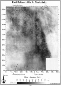 Site 2 was covered by a 100m (e-w) x 125m (n-s) grid ( Fig 4 ). This again largely confirmed the picture gained from air photographs. Two of the three palisaded enclosure phases were visible, although both showed signs of a pinch at their northernmost point, which gave them the appearance of a droplet, rather than the simple oval form seen from the air. The inner site was approximately 36m (e-w) x 41 (n-s) and showed signs of a greater reentrant at its entrance than shown in the Air photos. The outer site was slightly larger at c. 42m (e-w) x 46m (n-s). Further south, faint signs of the possible square barrows seen from the air were detected, one of which showed a central area of high resistance which might represent a stone cist. To the west of these features faint signs of a larger rectangular enclosure were detected for which there was no corresponding Air evidence. A further modern pipe was identified, to the east of the archaeological features, running almost due north for the entire length of the grid.
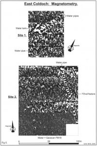
In addition to the resistivity work, the same grids were scanned by magnetometer ( Fig 5 ). As so often in this area, the high iron content of the subsoil acted to jam archaeological signals and the only additional feature to show was a possible large oval enclosure (c. 55m in diameter), to the southeast of the palisaded enclosures on Site 2. This did not correspond to anything visible from the air and its identity remains a mystery, although its shape does suggest yet another palisaded enclosure. The water tank on Site 1 and the pipes (although not the land drains) on both sites showed extremely clearly which suggests that they are made of cast iron.
The Excavations
To date, three seasons (totaling 6 weeks) of excavation have been conducted: a small test trench in 1996, followed by larger scale work in 2000 and 2002 (no work took place in 2001 because of the F&M outbreak). A fourth is planned for 2003. The work was conducted by the Roman Gask Project and directed by the first writer throughout, in concert with co-directors: Miss M.H. Davies, (as a training exercise) in 2000 and the second writer in 2002.
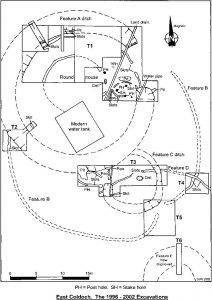 SMC was obtained for six trenches, all on Site 1 (Fig 6). Trench 1 was designed to investigate the northern half of ring feature “A”, including the possible internal structures and, if possible, to locate a continuation of palisaded enclosure “B” beyond the points to which it had been traced from the air. Trench 2 was intended to determine the stratigraphic relationship between Features “A” and “B”. Trench 3 was to study the possible cist burial, Feature “C” and determine its relationship with Features “A” and “D”, whilst Trench 4 was to look at the relationship between palisaded enclosures “B” and “D”. Trench 5 was designed to study the entrance to Feature “B” and look for any associated gate structures, whilst Trench 6 was to investigate the possible souterrain, Feature “E”.
Feature “E”
Despite being extended well beyond the feature’s rectified position, Trench 6 found nothing but undisturbed natural clay. The most probable explanation is that the crop mark was caused by some non-archaeological factor, such as uneven fertiliser spreading, which would also explain why it has only appeared once from the air. An alternative is that ploughing or the removal of earth for the burial of the modern water tank have destroyed any archaeological remains since the air photograph was taken in the 1980s, but this seems unlikely for a feature as deep as a souterrain and no other site type readily fits the crop mark’s morphology.
Feature “A”
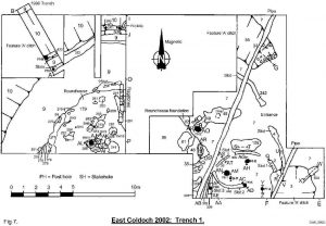 As stated, this large ring feature was initially suspected of being a Roman watchtower, but a single ditch section dug in 1996 (figs 7 & 8) was enough to dismiss this hypothesis (Woolliscroft & Lockett, 2002). For, instead of a classic “V” shaped Roman military ditch, the trench revealed a flat bottomed, bowl shaped feature, 4.3m wide and 1.36m deep from the base of the modern plough soil (1.6m from the surface). Immediately inside and parallel to both the ditch and each other, two slots were located, each of which produced a single posthole
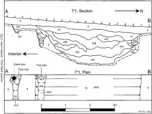 within the 1m wide trench. The outer (northernmost) slot was the broader of the two by a small margin, at 0.25m (as against 0.21m) and the features lay 1.04m apart at their centre lines. The two slots appeared to be broadly contemporary as both were overlain by the same loam and charcoal deposit (c332). The only posthole whose original form could be ascertained was that in the inner feature (Fig 8). The timber here had been stone chocked and had rotted in situ. It was rectangular in section and set at an angle of almost 45o to the lines of both the ditch and its own slot. It measured 0.15m x 0.12m and was sunk just 0.36m into the subsoil. The posthole in the outer slot was more substantial. Here the post itself had been removed, so no exact dimensions can be given, but the posthole was considerably deeper, at 0.67m and, at least slightly, wider at 0.16m. There was initially some uncertainty as to the stratigraphic relationship between the outer slot and the ditch. The first impression was that the ditch had been cut through an earlier slot’s upper fill, but the ditch’s outer face was more vertical than the inner and it remained possible that a more symmetrical inner face had collapsed at some point, taking part of a contemporary (or even later) slot with it. Moreover, the ditch fill layers presented an interesting picture, which led to speculation that the two slots combined might represent a box rampart of some sort.
The ditch had initially begun to silt naturally, probably over a considerable period, with a thick (up to 0.35m) layer of grey, waterlogged, primary silt (c444) overlain by an equally thick, fairly even, layer (c441) of gravely grey loam. These deposits, however, had then been partly buried by two layers which had clearly entered the ditch from the site’s interior. Context 439 was a band of mixed turf, which still preserved a complex jumble of carbonisation lines whilst, below this, c440 was a loose deposit of clean brown loam which appeared to have collapsed or been dumped into the ditch in one event, rather than being washed in over time. Context 436, a plough truncated deposit of grey/brown loam with charcoal flecks, which sealed the two post slots, might also have been turf derived and all of this would sit well with a rapid demolition or collapse event, perhaps involving the contents of a turf and earth filled bank or box rampart, for which the posts might have formed a revetment. Moreover, the surviving (sloping) shape of the top of the outer slot’s post hole might suggest that the post had eventually snapped off at, or just below, ground level and then fallen, or been pushed out into the ditch. On the other hand, the relatively small volume of material involved in these layers would suggest that only a fairly slight rampart was involved, which may have sloped down from the ditch face into the interior, hence the lighter timberwork at its inner face.
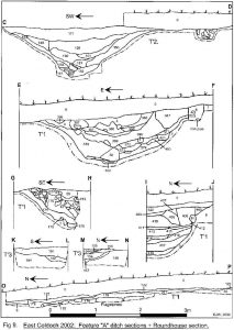 Two more full sections have since been cut, along with a number of partial sections (Figs 6, 7& 9) and these have revealed considerable variation in the ditch’s size and profile. Section C-D (Figs 9 & 10) cut thesouthwestern quadrant in Trench 2 and revealed a narrower, more “V” shaped ditch, 3.47m wide and 1.26m deep from the base of the ploughsoil. Section E-F, on the other hand, was cut close to the southern
  entrance butt end and yielded a rounded profile, 1.02m deep and approximately 3.4m wide (the western edge was disturbed by a modern pipe trench) which, along with the 1996 ditch, reached below the modern water table. A longitudinal section (G-H) cut through the northern butt end also produced a rounded profile. Indeed, only partial section I-J, cut less than 7m from the 1996 trench, yielded a similar steep sided, flat bottomed shape and even this appeared markedly shallower (at 1.09m), although it may be deeper towards its unexcavated centre. The site does, though, appear slightly more circular than the Air and geophysical evidence had led us to expect. It measures 31.8m externally from southwest to northeast (approx 23.5m internally) and 31.4m from northwest to southeast (24.7m internally), an average centre line diameter of 27.86m. The ditch came to fairly flat butt ends, with only a little prior narrowing (especially in the south) and left a broad (if slightly narrower than expected) 8.43m entrance break. This gives a dug circumference of around 79.2m, which means that its construction involved the removal of at least 190 cubic metres (342 tonnes) of earth, although a more realistic figure might be 280m3 (504 tonnes), if the ditch was originally cut from a level approximating the modern surface. If the builders could match the putative Roman work rates recently given by Shirley (2001, 41ff), this equates to roughly 224 man hours, although the Romans’ efficient tools and training in entrenchment construction probably make this over optimistic. These figures do not including the clearance of spoil, whose fate here remains unknown. No sign of an upcast mound was detected outside the ditch in either the excavations or the geophysical plots, so it may well have been removed from the site, but it is equally possible that the traces have simply been ploughed away.
The ditch fills show a reasonably consistent pattern, albeit some variation is evident. Above sometimes quite thin layers of primary silt, were deposits of material which seem to be weathering products from the varied natural sand and clay subsoils and which generally fill the ditch to about half its surviving depth. In some cases, such as section E-F c400, and especially section I-J c’s 414-416, some of the uppermost of these layers contained considerable quantities of charcoal.
Above these siltation deposits were occasional signs of turfy layers (e.g. section A-B c439 & section I-J c412. These may be the remains of buried surface layers formed once the ditch deposits had reached a stable angle of rest. Above these, the deposits were more loamy in nature and seem more likely to have entered the ditch through human activity, either deliberately, or accidentally as a result of plough action. A number of small partial sections also yielded similar upper fills (e.g. Fig 9, sections K-L & M-N, c’s 154, 155 & 191, and Fig 14, section L-CB, c’s 191 & 193). In addition, some layers (e.g. section A-B c438 & section G-H c170) were largely made up of mixed stones, suggesting that parts of the ditch were used as clearance dumps during later attempts to improve what is naturally a rather stony field.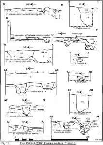
The ditch had been cut into by later features in several places, although sadly none produced datable material. For the most part this happened after it had been completely filled in, but section E-F c401 (Fig 9) would seem to represent a small cut made whilst the ditch was still silting. Elsewhere in the same section, c’s 366 and 398 fill the damaged remains of shallow pit and c347 might also have been cut into c369. Context 320 represents the fill of a small pit at the southern butt end (fig’s 7 & 11, sect W-X) and both butt ends were cut by the pipes leading northeast from the modern water tank (sect E-F, c8) which did indeed prove to be iron. Elsewhere, c406 in section I-J (Fig 9) represents a posthole set in a pit filled by c’s 405, 407 and 408 and this feature had itself been damaged by a shallow scrape filled by c409. Finally, the interface between c’s 128 and 148 in section C-D formed an almost straight vertical which seems unlikely to have formed naturally. This led to some speculation that the entire ditch may have been re-cut, with c’s 151, 160 and 161 being part of a secondary phase. But the evidence is far from incontrovertible and the vertical interface remains something of an enigma.
The post 1996 seasons have also provided a clearer view of the internal slots, and the box rampart hypothesis has not withstood the test of time. To the east of the original trench a further 5m of ditch has been revealed in plan (Fig 7). Only the eastern 2m has yet been excavated to full depth, but here the outer slot was again located (c349) and this time there was no doubt that it had been cut and largely destroyed by the ditch. Sadly the feature had been obliterated by the later posthole at the drawn section (I-J), but a further section will be recorded in 2003. The slot did, however, produce two more small posts, 1.1m apart. Although both were little more than stakes, at 0.1m in diameter, and only stumps, 0.12m deep, had survived the digging of the ditch. The inner slot was traced in plan throughout this extended sector, but no more postholes have yet been located within it and, again, a more detailed study will be conducted next season. Fortunately, both slots yielded quantities of charred wood which should be sufficient to provide dates.
 Towards the eastern end of Trench 1 two long sections of a single slot were uncovered (c’s 4 & 242) behind the ditch entrance. These too showed a distinct entrance break, this time only 1.67m wide and, again, the slot was initially assumed to be a contemporary inner defense. This was soon disproved, however, when the relationship between the slot and the southern ditch butt end was studied (Fig 11, sect U-V), for the ditch very clearly cut the slot and thus postdated it. Which, if either, of the two slots seen further west this feature represents will not be known with certainty until the intervening area has been excavated. Nevertheless, judging purely by eye, an extension of the inner slot seems plausible and the fill of the eastern slots, a brown, very sand loam, is certainly broadly similar. If this does prove to be the case, then both slots predate the ring ditch and so must belong to an earlier structure or structures, although there is, as yet, no firm evidence to show whether they were indeed contemporary inter-se. The eastern slots were searched thoroughly, in both plan and section, but no sign of posts was found set into them and no sign of a gate structure could be traced. The features were, though, very flat bottomed (apart from a slight dip visible to the north of centre in section U-V). It thus seems possible that they once held a fence mounted on a sleeper of some sort, perhaps supported by more widely spaced posts, such as that found in the inner slot in 1996.
A final length of slot was located inside the ditch in Trench 2 (Fig 9, sect C-D and Figs 10 & 12, sect AY-AZ). It was uncertain which, if any, of the slots found elsewhere this represented, but the fill (c144) did appear to be a stonier version of that from the inner northern slot. At the southeastern side of the trench it had been cut by a small pit (c143) but, although this may represent part of a posthole, it was not possible to be certain from the limited evidence available.
Inside both the ditch and slot defenses the well preserved remains of a large, burned down roundhouse were uncovered, approximately 11.9m in diameter and with its entrance probably oriented slightly north of east. Sadly no stratigraphic evidence had survived to make it certain whether this was associated with either defence, or even both in sequence. The only real clue was the presence of significant quantities of carbon in some of the ditch layers which might at least hint that the roundhouse’s destruction occurred at a time when the ditch was still in its silting phase and it will be interesting to see whether C14 dating bears this out.
Work on the roundhouse is still far from complete and so only a limited account can be offered here. Nevertheless, signs of a complex history have been revealed. The topsoil above the feature contained high levels of burnt material and the first in-situ layer encountered was a scorched sheet of beige clay (c.122) up to 90mm deep (Fig 9, sect O-P). This was badly plough damaged and only survived over the western half of the house, but appeared to have been a floor level. It may, thus, once have covered the entire internal area and on it were found a number of barley grains, a piece of hazel nut shell and a number of traces of spatter, indicative of metal working activity. The scorching and carbon suggested that this roundhouse had ended its life in conflagration and nothing was found to suggest that it had been rebuilt. Beneath it, however, lay an earlier (we cannot yet say primary) version and this proved to be in a remarkable state of preservation, especially for a crop mark site.
The removal of c122 revealed a further series of burning deposits. In the southern and eastern parts of the trench a very dark brown, sometimes blackened, layer was encountered (Fig 7, c80 & Fig 9, sect O-P, c63). This contained significant quantities of charcoal, possibly from birch, alder or hazel (see report by J.Huntley below) which might represent wood from the roundhouse structure. Copious quantities of datable carbon were recovered and, although most of the samples have been retained so that the whole site corpus can be processed together once the excavation is complete, a duplicate sample from this context has been processed and yielded a 2 sigma calibrated date of AD 110-330. Further to the north and west, a grayer material (c178) was found, which contained more ash than charcoal. This was partly examined in 2000 and already yielded a number of barley grains and a piece of hazelnut shell. More complete excavation in 2002 produced a great deal more carbonised grain and more nutshell fragments. Again, the grain appears to have been predominantly barley but, although Mrs Huntley’s report on this season’s organic finds is still in preparation, the writers’ own field impressions were that small quantities of wheat and oats may also have been present. Interestingly, barley chaff was found in the initial fill layers of the northern ditch butt end, suggesting that the grain was threshed and winnowed on site (possibly in front of the house) and this may add another potential connection between the house and the ditch. On the other hand, silt deposits taken from the ditch in 2000 have been examined by Dr S.Ramsay (report below) and yielded no cereal pollen. Instead, her analysis paints a picture of an almost treeless landscape given over wholly to grazing. Further samples were taken in 2002 so that a search for even trace quantities of cereal pollen can be made and it will be interesting to see whether the results remain consistent. At present, however, we seem to have the possibility that both roundhouse phases were obtaining grain that was not grown on or close to the site.
In addition to these principal layers, the burning deposits also contained a number of other elements. Both c’s 63 and 178 may contain a degree of peat ash. More significantly, however, both contained an admixture of burnt daub, which presumably derived from the roundhouse structure. There was also one narrow sheet (c291) of daub and charred twigs (perhaps from wattling), which ran roughly straight, and perpendicular to the roundhouse edge. This penetrated down to floor level and, although it cannot yet be regarded as proven, it may have been the base of an internal partition. The burnt material was otherwise fairly homogenous. No finds or large charcoal fragments were located and the material had an unusually fine particle structure. This gave the impression that the building’s remains may have been raked after its destruction, perhaps to recover items of value.
Below the burning lay an earlier floor (c179), primarily of laid clay, but with a number of turfy patches (c.283) and progressively more heavily burnttowards the south and east (Plate 1).  As yet the floor remains far from fully excavated, but a small test section (O-P) showed that it was up to 130mm thick and had been thoroughly baked to its full depth. The natural topography of the site would create a slight downward slope in the roundhouse floor from south to north and, to compensate for this, the northern part of the floor was found rest of a layer of flat stones. These were initially interpreted as a floor layer in their own right, but they were rough and completely unworn and appear to be make up, although they still leave a slight slope towards the house edge. They were, however, also badly scorched on their upper surfaces and this evidence combines to imply that the structure burned down in something of an inferno. On the other hand, the roundhouse’s northwestern edge was almost untouched by fire and the clay still retained its natural pink/brown colour. It might, thus be more than mere speculation to suggest that the fire took place during a dry spell when the structure would burn well and that the flames may have been fanned by a northwesterly wind. No sign of a hearth has yet been found, but the building’s exact centre has yet to be excavated.
A number of small finds were recovered from the early floor, including several iron objects. These were very corroded and are currently in the National Museum of Scotland for conservation. The writers’ initial impression was that one was a knife blade and another a chain, but confirmation will have to await expert analysis. Perhaps more importantly, however, a sherd of glass from a late first century Roman square bottle was found, which is currently the only datable material recovered apart from carbon.
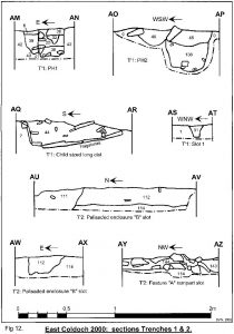
A number of features were located cutting into the floor, including two small postholes, a number of stake holes and a series of, often inter-cutting, pits. All had very heavily burned fills. Postholes, 10 and 11 had their entire pits cut through the early floor. This might not be decisive, but one might have expected a roundhouse floor to have been laid after the superstructure had been built, so that only the posts themselves would have protruded. The situation would thus suggest that the posts belong to the secondary roundhouse, although its floor was not well enough preserved to allow any corresponding features to be detected and their similar fills prevented their being seen in the early destruction deposit. Posthole 10 has not yet been fully excavated, but the stone chocked post seems to have been square and 0.14m across. The stone chocking survived well and, as there was no sign that the post had been removed, it was probably destroyed by fire. Posthole 11, on the other hand, appeared to have been dug out (c’s 422-4). This feature has been sectioned (Fig 11, sect AK-AL) and the bottom of the original post pipe located (c425). The post seems to have been c. 0.1m wide and was set 0.33m deep from the early roundhouse floor.
Four stake holes were found inside the roundhouse (Fig 7, SH’s 3-6). These were very slight features, often less than 60mm wide. Their role is unclear, although SH’s 3 and 4 may form a radial line from the house edge towards the centre. Their stratigraphic position is also unclear, although SH6 had been driven into the fill of a pit (c313) which was itself cut into the early roundhouse floor.
In addition to the post features, a total of eight pits were revealed cut into the floor, all of whose fills were burnt. These seemed to form two distinct groups. The first lay towards the southern edge of the trench and involved c’s 238, 241, 288, 289 and 290. Most of the stratigraphic relationships between these features remain unknown, but section AI-AJ (Fig 11) did show that c238 post dated c288, whilst section AK-AL proved that the demolition pit for posthole 11 (although not necessarily the posthole itself) also postdated c288. The second group was slightly further to the north and involved c’s 311-13. At present, these features have only been examined in plan, but the impression gained is that c’s 311 and 312 cut, and so postdate, c313.
Feature “C”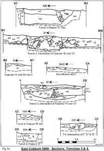
From the air, this much smaller ring feature had appeared more or less circular and its ditch had looked fairly uniform, but excavation revealed a less tidy picture (Figs 6, 13 & 16). Trenches 3 and 5 combined to produce a distinctly sub-circular or even sub-rectangular ditch (c’s 119, 200, 248 & 332). It varied in width from 2.02m to 0.98m to give an average centre line diameter of 10.27m. It’s profile and depth also varied considerably. In the east it had an almost rectangular section, 0.39m deep (Fig 14, sect BV-BW). Further 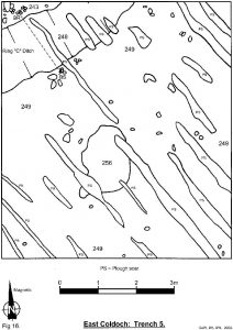 west (Fig 15, sect BP-BQ) it was a shallow “V” shape, 0.55m deep whilst in Trench 5, to the south, it was a flattened bowl shape, 0.41m deep. The Air indications had been of an unbroken circuit, but the excavations showed the ditch to peter out into a series of small pits (c’s 66-71) for a 2.8m stretch in the west. Fortunately, the ditch reappeared (c200) in time for a section (Fig 14, sect L-CB) to show that ring ditch “A” had cut it and was thus later. Feature “A” had then, in turn, been cut by a later pit (c195) and then by the trench for an iron pipe from the water tank (c201).
Apart from very thin silt layers at its bottom, the ring “C” ditch had been almost exclusively filled with layers of clay, most of which had an admixture of loam and so may represent the material originally dug out of it. The only exception was c384 in section BP-BQ which appeared to be buried surface material with a high organic content. This may have been a topsoil formed in-situ in the partly filled ditch, but it could also be surface material dumped or ploughed into the ditch during its infilling.
Features “B” and “D”
Trenches 2, 3 and 4 (Figs 10, 13 & 17) found signs of the two 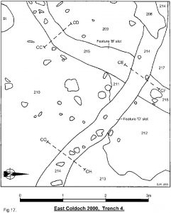 palisaded enclosures suggested by the Air evidence, and a clear stratigraphic sequence was established between the features, both inter-se and with other structures on the site. The Feature “B” slot was cut by the Feature “A” ring ditch in Trench 2 and is thus earlier (Fig 12, sect AU-AV). It was also cut by the Feature “D” slot in Trench 4 (Fig 14, sect CE-CF) and, as Feature “D” itself proved to predate the ring “C” ditch (Fig 14, sect BV-BW & Fig 15, sect BI-BJ) the site’s main chronological sequence can be fully reconstructed. Feature “B” is the earliest known structure on the site, followed by “D”, “C” and finally “A”. The excavation revealed an additional length of the Feature “D” slot (c74), to the west of the Feature “C” cist (albeit with a break between it and the known section) that had not been visible from the air, but parts of Feature “B” may have been ploughed out since the air photographs were taken in the 1980’s. This is perhaps unsurprising, as both slots proved to be very shallow and thus easy to destroy. The Feature “B” slot varied between 58mm (Fig 14, sect CE-CF) and 190mm
(Fig 12, sect AW-AX) in depth and between 0.24m and 0.65m wide. The Feature “D” slot varied between 30mm (Fig 15, sect BE-BF) and 280mm (Fig 14, sect BV-BW) deep and between 0.27m (Fig 15, sect BG-BH) and 0.57m wide. A careful search was made in the northern part of Trench 1 to try to find more of the Feature “B” slot, but without success. Moreover, no gate structures or other trace of the feature’s entrance was found in Trench 5, despite fairly good Air indications and repeated cleaning of the trench. A re-survey was conducted to confirm that the trench did match the air photo rectified position and the trench was enlarged to provide a greater margin for error, but still without result. A leveling survey of the trench floor did, however, reveal a slight hollow in the subsoil running on the expected entrance axis and it seems likely that the feature has been totally erased at this point.
The excavations have confirmed the Air indications that Feature “B” had a diameter of 37.2m. Not enough of Feature “D” has been seen from the air to form a precise measure of its size. Indeed it remains uncertain whether it did make a complete circuit but, assuming it was reasonably regular, the new 7m length in Trench 3 would allow an estimated diameter of 36m, which fits well with the room available before the break of slope to the south. These dimensions are broadly comparable with the enclosures to the north of the modern road although, at present, the relationship between the two groups must remain unknown.
Features “B” and “D” have been categorised as palisaded enclosures, but one notable aspect of both is that no post or stake holes were found in either slot, despite the emptying of considerable lengths of their fills. As with the “palisade slots” inside Feature “A”, however, they tend to have flat bottoms (except Feature “D” in Fig 15, sect BE-BF) and may have held sleeper founded fences rather than true palisades. Indeed the features might even have been bedding trenches for hedges, albeit no associated root holes could be detected.
Other features
The excavations added a number of new features to those seen from the air. The first was a series of curved slots found towards the east of Trench 1 and the west of Trench 3. The most complete circuit (albeit with breaks) was slot 1 in Trench 1 (Fig 7, c’s 2, 35, 303 & 305). To date the work has revealed almost half of a circle with a diameter of c. 6m, with c2 containing nutshells, a bracken frond and a some barley. The slot contained no post or stake holes but, again, had a flat bottomed profile (Fig 11, sect AA-AB & Fig 12, sect AS-AT) which may have contained a light sleeper of some kind. The easternmost part of the slot was cut by the Feature “A” ditch, which thus postdates it (Fig 11, sect Q-R), whilst c305 had been damaged by a pit whose fill contained a fragment of clay tobacco pipe (Fig 11, sect S-T, c108). A second slot (slot 2) was found inside this first (c446). Only a short length was traced, but the curve of the surviving feature suggested a smaller total diameter. The feature was badly ploughed out with only a few millimeters of its depth preserved, but the stump of a post hole (PH5) was found set into its eastern end, 0.22m wide and surviving to a depth of just 0.12m (Fig 11, sect AC-AD). A second, almost identical posthole (PH4) was found a little further to the east (sect Y-Z), although it does not appear to lie on any likely extrapolation of the slot’s circuit. Likewise, a single very slight (60mm diameter) stake hole (SH 7) was located a little to the north of slot 2, but its date and context also remain unknown.
It was not possible to determine the stratigraphic relationship between slots 1 and 2, as the two never quite touch. They do, though, seem to be on an intercepting course and so seem unlikely to be contemporary. Both, however, cut (and so postdate) a third short length of slot (c309). Here too, a posthole (PH6, 0.23m wide x 0.26m deep) was found cut into the feature, whose bottom was very variable in depth, ranging from 86mm to 0.25m within little more than 1m (Fig 11, sections AA-AB & AE-AF). There were also some indications of yet another slot immediately to the north of the Trench 1 roundhouse (Fig 7) which will be further investigated next season. Part of a final, tightly curving, if shallow slot (c58) was found in Trench 3 (Fig 13, slot 4). This was again flat bottomed and apparently posthole free (Fig 14, sect BZ-CA) but it was not possible to establish its stratigraphic relationship with any of the site’s other features since, although it came to within centimeters of the Feature “A” ditch, the two didn’t quite touch (sect BX-BY). All that can be said is that it was cut by a pit containing early 20th century building rubble (c271) which also cut the Feature “A” ditch and is probably associated with the water tank. The slots’ likely diameters are all much smaller than the Feature “A” roundhouse and seem consistent with groove houses, but no internal features were detected. All fall outside the circuit of palisaded enclosure “D”, but inside Feature “B” and, although there is no stratigraphic evidence to prove it, they may well represent internal structures belonging to that feature.
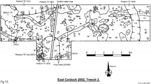 In addition to these relatively small diameter features, two more slots were found in Trench 3 (Fig 13) that may have belonged to larger structures. Slot 5 (c’s 333 & 361) lay in the trench’s southwestern corner, and varied between 0.3 and 0.48m wide and between 0.14 and 0.29m deep (Fig 15, sect’s BA-BB, BC-BD & BD-BM). Only a relatively short 4.8m stretch was revealed, but its rate of curve, if continued, would suggest an overall diameter of around 30m. No trace of this feature has been seen from the air and nothing was detected by the geophysical surveys, but such a size would be comparable to the site’s existing palisaded enclosures. Indeed extrapolations of the known line make it possible that the internal slot found in Trench 2 and one of the palisade slots in the northwestern part of Trench 1 may be part of the same structure (Fig 6). The slot was found to contain a single posthole (Fig 13, PH 12) more substantial than any found in the other palisaded enclosures, at 0.28m wide x 0.33m deep (Fig 15, sect BK-BL), but it otherwise shared a similar flat bottomed profile. As yet no stratigraphic evidence is available to determine the slot’s relationship with any other feature on the site, although it stops just short of crossing Features “C” and “D” (sect’s BC-BD & BD-BM). However, the excavation’s SMC will allow a 3m westward extension to Trench 3 in the 2003 season and an extrapolation of the slot’s curve suggests that it should intercept the Feature “A” ditch within this area. The eastern end of the known length has a slightly swollen appearance and might represent one side of an entrance break but, if so, no sign of an answering slot was found further east in Trench 3.
Slot 6 was located in a southern extension to Trench 3 (Fig 13, c330) and proved to cut, and so postdate, the Feature “C” ring ditch (Fig 15, sect BP-BQ). Unlike any of the other slots on the site, it appeared to run straight, although, as yet, only a short (1.9m) section has been uncovered. The slot was 0.2m wide and up to 0.3m deep (sect BM-BO) and stopped abruptly at full depth about one third of the way across the ring “C” ditch. Shortly before the terminus, two 0.23m deep postholes were found, 0.26m apart, from which small amounts of carbon were recovered. Hopefully, these will be sufficient to provide a date since, again, there are no indications of the feature in the Air or geophysical data and so its identity and role on the site remain otherwise unknown.
In the east of Trench 1, three postholes (PH’s 1, 2 & 3) were discovered which were noticeably larger than those already described. PH1 was 0.27m wide and 0.3m deep (Fig 12, sect AM-AN). PH2 was 0.43m wide and 0.43m deep (sect AO-AP) and PH3 was 0.35m wide and 0.48m deep (Fig 11, sect AI-AJ). The three are not identical but are consistent enough that they may well belong together and this impression is further borne out by the fact that together they form two lines (PH1-2 & PH1-3) which meet at an almost perfect right angle. Moreover, a possible fourth posthole (?PH7) was located to the northeast of PH2 and, although time has not yet allowed this to be excavated, if confirmed in 2003 it would complete a near perfect rectangular structure measuring 4.65m (nw-se) x 2.32m (an aspect ratio of 1:2), oriented towards the Feature “A” ditch entrance. Quite what such a structure might be is uncertain, especially as there is, as yet, no stratigraphic link between the posts and any other feature. It was initially assumed to be a porch for the Feature “A” roundhouse but, although the southern side of the roundhouse entrance has not yet been located, making it impossible to determine its exact size and orientation, the post feature would appear to be oriented more to the northwest than any likely entrance reconstruction. This is probably not conclusive in itself, for there may be a functional reason for an angled entrance porch. One could also suggest that it is anachronistic to expect symmetry in ancient native architecture, although here the post structure’s own precise layout might serve as a counter argument. Nevertheless, the posts may represent a separate, free standing structure, possibly one of the so called “four posters”, identified at other Iron Age sites in the region. These have sometimes been associated with (possibly elevated) grain storage and there is certainly plentiful evidence for activity concerning grain in this part of the site. Some of this has already been mentioned, but the fills of PH1 contained weed seeds and over 1,900 barley grains, whilst PH2 contained barley in smaller amounts.
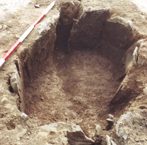
Finally, an unusually small long cist was found just outside the 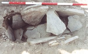 main roundhouse entrance in Trench 1 (Fig 7 and Plates 4 & 5), with its long axis oriented almost perfectly north-south. At present, the cist’s stratigraphic position remains unknown, but levels survive which may be able to improve the situation and it will be particularly interesting to test the possibility that it may be contemporary with one or other of the roundhouse phases. Whatever the case, the feature was beautifully preserved with its side and floor lining of thin flat stones surviving almost perfectly (the northern end stone was displaced into the fill), along with one of its cap stones. The miniature cist was 1.03m long x 0.28m wide, just large enough for a baby or very young infant, and its floor sloped down towards the south, to give a surviving depth that varied from 0.26m to virtually nothing (Fig 12, sect AQ-AR).
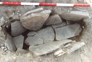 As with the Trench 3 cist, no signs of a burial or grave goods were detected. Instead the feature had a uniform fill (c44) of dark brown, slightly silty sand, little different from the natural subsoil around it. Quantities of carbon were present in this fill, which may be enough to provide a date, whilst floatation produced a single unidentifiable cereal grain.
Acknowledgments
The writers are grateful to the farmer, Mr D Graham, for allowing access to the land and for his help in machine backfilling the excavation tranches. We also thank our many student and volunteer diggers who hailed from eight countries in three continents. In particular, we thank our loyal and very professional team of trench supervisors: Miss A.T.Hamel, Miss A.J.Hughes, Dr N.J.Lockett, Mr T.Loughlin, Mr K.B.Miller and Miss S.Moore, along with Dr D.Simpson for his medical services. Off site, we thank Mr and Mrs A.D. and E. Graham for providing accommodation, Dr S.Ramsay and Mrs J.Huntley for their environmental analyses, Mrs A.C.Finnegan for her lithics work, C.R.Craig for examining the bone fragments, Historic Scotland for granting Scheduled Monuments consent and the BBC’s “Time Flyers” program for funding the C14 date. The Roman Gask Project is based in the University of Liverpool and sponsored by the Perth & Kinross Heritage Trust.
Bibliography
Maxwell, G.S. 1983 “Cropmark Categories Observed in Recent Air Reconnaissance in Scotland.” Scottish Archaeological Review 2(1), 45-52.
Shirley, E.A.M. 2001 Building a Roman Legionary Fortress, Stroud.
Woolliscroft, D.J. and Lockett, N.J. 2002, “Excavations and Survey at the Ring Ditch of East Coldoch, Blairdrummond”, in Woolliscroft, D.J. (ed) The Roman Frontier on the Gask Ridge, Perth & Kinross, BAR (British Series) vol 335, 46-51.
Discover more from The Roman Gask Project
Subscribe to get the latest posts sent to your email.