

The Roman Gask Project.
Annual Report: 2005.
Fieldwork.
2005 has seen another busy field season with the completion of our long-standing East Coldoch excavation; another in our series of large, whole Roman fort, geophysical surveys and a continuation of our air photographic program. As always, our work has attracted volunteers from a wide geographical area, with diggers from Canada and the USA taking part alongside those from the local area and the UK as a whole.
Excavations.
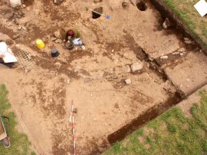
East Coldoch.

A final season was conducted on this well preserved Roman period, Iron Age settlement and it continued to yield fascinating data. At the end of the 2004 season we thought that we had four building periods in the main, 13m diameter, ditched roundhouse. This was somewhat speculative, however, as we had only seen the very earliest levels in two small test trenches and in areas where they had been revealed by plough damage. The bulk of the work had been restricted to the third period and the badly plough damaged remains of the fourth. The third house interior was marked by a large area of paving and this was finally lifted in 2005 to give greater access to the earlier levels. Beneath it, we already had indications of a so called “ring ditch” house: a roundhouse with a shallow ditch immediately inside its walls. The presence of this feature was confirmed and the full extent of the ditch within the area for which Scheduled Monument Consent had been obtained was revealed. It proved, as expected, to be a shallow, saucer-shaped affair, perhaps well suited to collecting manure from stalled cattle. We had expected it to continue almost as far as the house’s east facing entrance, but in fact it stopped well short of it. This house was shown to have burned down, like its successor, although probably with rather less ferocity, for there were fewer of the signs of really high temperature conflagration that marked the end of the third phase.
Beneath the second house, a more detailed view of its predecessor was obtained, although plough damage in the south, and the digging of the later internal ring ditch further north, had largely obliterated the occupation levels. There were, however, a number of surviving postholes and the stratigraphic information provided by some of these being cut by the 2nd period ring ditch has made it easier to disentangle the phasing of the sea of posthole stumps that have been stripped of their stratigraphic placement by ploughing elsewhere. Each of the four main roundhouse periods seems to have had slightly different posthole designs and fill patterns, and it should now be possible to assign each to its rightful place in the site’s history.
Once the primary layers of the main roundhouse had been removed, signs of a series of still older features were revealed. Firstly, the palisade slot of the earlier of two palisaded enclosures, already seen elsewhere on the site, was traced. Inside this was a series of much smaller roundhouses, which closely resembled those found further to the west, also inside the palisade slot, in 2002. No stratigraphic link had survived between the slot and these foundations, but it does not seem unreasonable to assume that the houses represent internal settlement features. Moreover, as some of the house foundations inter-cut, the palisaded enclosure may have remained in use long enough for them to need rebuilding. Certainly, there are no signs that the houses burnt down, rather than wearing out through time. The palisaded enclosure had been more or less expected, but another feature came as a complete surprise. This was a rectangular enclosure marked by a light ditch or slot, c. 0.3m across. Its full, approximately 4m, n-s width was revealed within the trench, but it extended beyond the excavated area to the west, with only c. 4m of this axis visible. The trench had by then already reached the full extent allowed under our SMC grant and could, thus, not be extended, so the feature’s full extent still remains unknown.
To the northwest of the main house, a new area was opened to further investigate the main roundhouse ditch, along with a series of ephemeral, later features found in 2003, which may have had a funerary function. A few more faint traces of the latter were revealed, but little more can be said about their nature. The massive roundhouse ditch itself, however, continued to show the same steep sided, flat bottomed profile as before and had again been re-cut several times.
As in previous seasons, the preservation of organic materials was superb, with grain and hazelnut shells again being particularly abundant, and C14 datable carbon was recovered from many of the critical contexts. Most of the grain was barley, but previous seasons have revealed oats and wheat, including bread wheat. As in 2004, possible grape pips were produced during sieving, which might come from Roman wine sediment, but seem more likely to derive from imported raisins. If so, this may be another example of a taste on site for Roman foodstuffs to go with their taste, seen in previous seasons, for Roman beads, glass and pottery. No further Roman artefacts were recovered from these earlier layers, some of which probably predate the occupation, but there were plentiful signs of metal working, in the form of furnace lining, slag, crucible fragments and a small, ceramic, casting mould.
In previous seasons, the site had developed quite a tradition of springing a major surprise on us at a time too late in the dig for anything to be done about it. As a result, although each of the last three seasons had been intended to be last, we always ended up having to return. This year, however, we finally seem to have got the place cornered and, although the early rectangular enclosure did come to light over the final two days, there was still sufficient time to investigate it as fully as was possible within the available area. As a result, the site really is now finished, after five excavation seasons, and we can begin writing the report. This may take some time to see the light of day, at least in its final publication version, simply because of the huge amount of specialist, and particularly environmental, work that needs to be completed first. We would, however, hope to have an interim draft, dealing just with the archaeological features available on the Gask Project’s Web site, well before this and the legally required Data Structure Report is already in preparation.
Geophysics and remote sensing.
For the last few years the Project has been conducting a series of very large geophysical surveys, taking in entire Roman forts and their surroundings, and we are eventually hoping to survey most of the forts to the north of the Forth-Clyde line. This year we were able to survey the larger of the two forts at Cargill, on the Tay/Isla confluence, to the north of Perth: the smaller fort having already been covered in 2003. In addition, we have also produced new air photo derived plans for many of the other Roman forts to the north of the Forth and Clyde that we have not yet surveyed. The latter work was occasioned by our forthcoming book on the Flavian occupation of northern Scotland, of which more will be said below. Surprisingly, no plans have ever been published for a number of the sites, whilst the plans of others are often out of date (sometimes dramatically so), or seemed otherwise incomplete or inaccurate. In all, six auxiliary forts and parts of the Inchtuthil legionary fortress complex have been newly planned, along with a number of temporary camps. This work was greatly helped by the kindness of the RCAHMS, who made available their own air photo rectifications of some of the sites, and by Headland Archaeology Ltd who gave us a copy of their excavation plan for the fort of Doune. But in all cases we have also made new rectifications, and added data from our own air photographs and those of others.
Cargill.
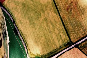
The auxiliary fort at Cargill (NO 166379) lies c. 9 miles to the north of Perth and c. 270m to the east of the smaller fort. It sits on a slight rise to the south of the Isla, a few hundred metres above its junction with the Tay, and represents, in effect, the foot of Strathmore. It was found from the air during the Second World War by Flt Lt Eric Bradley, who was then an RAF instructor, stationed at Scone airfield. Bradley himself seems not to have taken photographs, because of the war-time shortage of film, but fairly accurate sketches of both installations survive in a 1941 correspondence with O.G.S. Crawford (now in Perth Museum), and both sites have since been photographed many times (e.g. Fig 3).
Aerial views show a fort of around 4.8 acres over the rampart, with an annexe to the north. There are signs that both fort and annexe had a triple ditch, at least in places, with so-called”parrot beak” breaks at the entrances. The site was partially excavated, by the late Prof J.K. St. Joseph in the 1980s, but although, sadly, no report was ever published, short notes have reached print, and suggest a complex history, involving several rebuilding phases. Indeed G.S. Maxwell, who took part in the work, has informed us that some parts of the fort might show up to six structural phases.
Our own work on the site consisted of an 18-acre resistivity survey and a somewhat smaller magnetometer survey (Fig 4).

For the resistivity work, the fort itself was scanned at 0.5m intervals using a Geoscan RM15 resistivity meter fitted with a multiplexer, which allowed one 1m and two 0.5m electrode separation readings to be taken simultaneously. The remaining area was covered by another RM15 taking readings at 1m intervals with a 0.5m electrode separation. The magnetometry was done with a Geoscan FM256 fluxgate gradiometer, with readings again at 0.5m intervals. The survey greatly clarified the ditch system and revealed a rather longer section of the annexe defences than had shown from the air. We now have a 166m length of its northeast defences, which run at a slightly more westerly angle than the fort’s defences. These end on the edge of an obvious erosion terrace, just short of the modern river bank: which means that the NW defences may have been washed away. Alternatively, the annexe might originally have run right down to the water, but been left open at the bank, to use the river as a defence, or even to act as a defended landing area. For the Isla is easily navigable by small craft at this point (and for many miles upstream), and so supplies could have been brought in by water. As yet, there are no signs of any western annexe defences, which may have been destroyed by the modern A93, so its total area cannot be measured. The entrance arrangements, both between the fort and the annexe, and between the annexe and the outside world are also interesting. At the fort’s NE corner, the geophysical survey showed the triple ditches running together to form a single line, which appears to run along the whole of the NW side, except for a simple gate break which led into the annexe interior. The only external entrance through the surviving annexe defences lies at the fort’s NE corner. Here the coalescing fort ditches produce the effect of one half of a parrot-beak and one might have expected the annexe ditches to mirror this. Instead, they form what is in effect a reverse parrot-beak, in which the inner ditches swing out to joint the outer, rather than, as is usual, vice versa. The result is an entrance, c. 11m wide but, even assuming the presence of an annexe rampart, the nature, and even the existence, of any gate structures can only remain speculative. Inside the fort, the survey added a little more information regarding the street grid, but no sign of the (almost certainly timber) internal buildings was revealed.
As with many of our other fort surveys, the work also shed light on non-Roman activity. Air photography had already revealed a roundhouse inside the annexe and another just inside the fort’s NW gate. The geophysical survey confirmed that aerial evidence, but it also added two more important details. The first was a knot of ring features, to the east of the fort’s SE corner, which may be a group of small roundhouses. Perhaps more importantly, however, a c. 19m long, curving feature, which probably represents a souterrain, was found attached to the north gate roundhouse. Without excavation, the chronological relationships between these features and the Roman site must remain uncertain, but the strength with which the internal features show, both on air photographs and through geophysics, might suggest that they post-date (and so overlie) the Roman occupation. The survey also revealed extensive areas of rig and furrow cultivation overlying the fort itself and extending off to the east. Past aerial views had suggested the presence of a number of rectangular buildings lying immediately outside the fort’s eastern defences, but the survey suggests that these were actually optical illusions caused by parts of this rig pattern.
The St. Joseph excavation produced few finds and these have never been properly analysed, but the published notes suggest that what material there was points to a Flavian only occupation, probably ending in the mid AD 80s. This dating picture was greatly complicated by coin finds made during our survey, however. These include coins from very early in the reign of Vespasian (69-79), one of which showed little or no wear, and so might be a hint of earlier than anticipated occupation. As expected, there were coins of Domitian (81-96), but the really big surprise was two coins of the 2nd-century emperor Hadrian (117 – 138 AD). Both were found in worn condition, suggesting lengthy circulation before loss, and this might be a pointer to Antonine (or, just possibly, Severan) occupation. We know that the forts on the Gask frontier (Camelon, Ardoch, Strageath and Bertha) came back into use in the mid 2nd-century as outposts to the Antonine Wall and, some years ago, we were also able to show that the so-called “Glenblocker” fort of Dalginross also showed this pattern. It now seems likely that we have yet another Antonine outpost and this may well prove not to be the last. Whatever the case, however, this may help to explain the extraordinary number of structural phases found during the excavation.
Lastly, the site also produced two mid 3rd-century radiate copies (official coin forgeries), one of which may date to the reign of Claudius II (268-270 AD). At present we have no indications of a Roman military presence in Scotland at that time and so these coins may well come from the nearby native settlement (although other Claudius II pieces are known from our study area) and it will be interesting to see what future excavations might reveal. One thing is certain, however, for it now seems more important than ever that the St. Joseph excavations should finally be fully published, in the hope that they might provide greater insight into the site’s more complex than expected history, and give us some chance of deciding which of the structural phases were Flavian and which belong to a later period (or periods).
Our other new fort and camp plans involved modifications to existing views of Doune and Drumquhassle, much larger re-workings of plans of Steed Stalls, Malling and Dalginross (Fig 5),
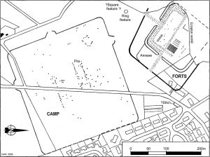
along with what seem to be the first ever plans of the forts and camps at Stracathro and Bochastle. One of the most simple, yet fascinating pieces of work concerned Inchtuthil, however, and consisted of nothing more than accurately combining the plans of two different excavations in the area of the so-called “Officers’ compound” to the southeast of the legionary fortress (Fig 6).
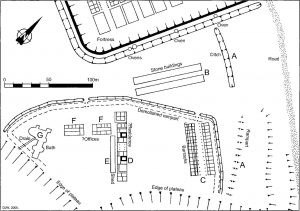
This area was partly excavated by Abercrombie in 1901 and further areas were dug by Richmond between 1952 and 1965. For some reason, however, when Richmond’s work came to be published, no attempt was made to incorporate the earlier results. This is regrettable, as the Abercrombie work suggests a much more complex structural history. Richmond himself revealed two periods in a set of timber barracks at the northwest end of the compound (Fig 6, C): the second of which was only built after the demolition of the compound’s defences. Abercrombie, however, had already revealed an extra set of defences (Fig 6, A) further west, along with a pair of long rectangular stone buildings which also look to be barracks (Fig 6, B), in the area between the compound and the fortress. Abercrombie also revealed a number of Roman military style ovens set in the fortress ditch, which seem to suggest activity on the site after the fortress was abandoned, and the new plan provides a more complete view of all this activity than any that has been published hitherto.
Air Photography.
2005 was a mixed cropmark season. Some areas were unresponsive, with some “old faithful” sites not showing at all. On the other hand, other areas were better than we had ever seen them and we were able to make a number of productive flights, which resulted in some 1,900 new photographs. As ever, new discoveries were made, although we won’t know how many until the pictures are fully catalogued. As in previous years, our flights were made from Scone airfield, and we are, as always, immensely grateful to Bill Fuller for volunteering his services as pilot. Bill has also, this year, created a searchable computer database of all of our air photos to date, which is far more flexible than our existing paper based index, and should make our rapidly growing archive easier and more productive for both ourselves and outsiders to use.
During the year, we also have managed to catalogue the whole of the bumper harvest of aerial pictures taken in 2004. In all, some 2,100 photographs were analysed, digitised and catalogued, and CD-R sets have been distributed to the Project’s members and sponsors, and to other interested bodies. Now that this process is complete, we have a record final total of over 100 new sites found in that year: ranging from indeterminate cropmarks, to souterrains, pit alignments, Highland clearance ruins and many ring features, which appear to represent Iron Age settlement. That such a rich harvest is still possible in an area that has been flown for more than 60 years might require some explanation. Part of it is no doubt due to the notoriously capricious nature of archaeological cropmarks. Certain features simply do not show very often and, of our new sites, some may never have shown before, whilst for others, the luck of the draw may have meant that they were missed on any previous showings, either because no one flew over them at the right time, or because any workers who did fly over, failed to spot them. The bulk of our growing haul, however, both in this year and others, probably reflects the way that we fly, rather than the archaeology itself. In the past, most of the archaeological flying within the Gask Project’s study area was done by two national bodies: the Cambridge University Air Photographic Unit (CUCAP) and the RCAHMS. The contribution of both organisations has been immeasurable and we have boundless respect for both, but their work has suffered from a few slight problems which were mostly not of their making. Firstly, both had vast areas to cover with the limited amount of flying time that could be mounted within the bounds set by the short length of the cropmark season and their available funding, which means that their attentions have been spread fairly thin. Secondly, in order to maximise the returns on their flying, there has been a long-standing temptation (common to all aerial archaeologists) to fly known, so called “honeypot”, areas again and again, where the soils are such that the crops are particularly responsive. For example, the RCAHMS’s GPS recorded flight tracks for the decade from 1993-2003 have recently been published and show a high level of consistency over that period, with some areas flown many times, but with obvious gaps elsewhere. The appeal of such an approach is obvious and, to a degree it is perfectly sensible. From a purely cost/benefit point of view, for example, it gets a guaranteed and relatively predictable return from the limited resources available. It does, however, mean that other areas can become relatively (or even completely) neglected, simply because they do not (or are simply not known to) produce above average levels of cropmarks, which in turn gives an obvious potential towards biasing the data. For, the resulting site distribution maps will tend to reflect the distribution of aerial attention and, less directly, of certain soil types and agricultural regimes, which may or may not reflect actual ancient realities. One of the great strengths of a flying program such as our own, which is restricted to a fairly tightly defined study region, is that we do not need to take this approach. We too have a very limited time in the air, around 12 hours per annum, and there is certainly a great temptation for us, too, to stick to the honeypots, with their guaranteed returns. This would, however, put us in a position where we were doing little more than duplicating the efforts of others and so, when we formulate flight plans, the question “where haven’t we been before” is given particular weight. We do, of course, still fly the especially productive areas, but they are not given undue priority. Instead, we aim more towards building total coverage, albeit cumulatively over many years. As a result, a lot of our new sites are found in areas that are rarely if ever flown by other archaeologists and although we may, quite predictably, see fewer sites per unit of flying time in such areas, a far higher proportion of those we do see are new discoveries.
We have also tried to combat another bias whose potential is built into the Project’s very soul. Since the dawn of aerial archaeology in our study area, with figures such as O.G.S. Crawford and Eric Bradley, during and just prior to WWII, there has been a marked tendency for Scottish aerial archaeology to be dominated by workers whose primary interest lay with Roman sites. The Cambridge unit’s work was for decades dominated by its founder, the Romanist Prof J.K. St.Joseph, and much of the RCAHMS’s work was led by another Romanist, G.S. Maxwell. Both men were giants in their field and it would be grossly unfair not to stress that both have contributed enormously to aerial studies of other periods. Nevertheless, their flying patterns often seem to have concentrated on areas which were known to have seen Roman occupation, and where Roman sites were either known, or might reasonably be expected. As the Roman Gask Project, it would be absurd not to admit that we too have a particular bias towards the Roman period, but it long ago became obvious that this cannot be understood by looking at Roman sites alone. An understanding of the contemporary Iron Age population is at least as important and, just as our excavation program takes in native sites, so must our aerial work: which thus requires wider coverage. In the process, we are also likely to create a broader picture for many other periods, but in a way that is simply to claim a virtue of what is anyway necessary for our own research priorities. The results seem to prove the theory, for we are gradually putting large numbers of Iron Age (and other) sites onto the map in areas which were previously almost blank, and, as a result, we feel that we justify the time spent and the funding provided by our sponsors, far better than we would have done by flying exactly the same areas as everyone else.
In addition to the new sites, we also obtained better views of numerous known sites, which have added important extra details. Of the latter, one of the most interesting was some particularly clear images of a double-ditched enclosure at Woodhead, between Perth and the Roman fort of Cargill. The site has been known for many years, and classified, simply as an enclosure; but the new pictures make it appear all but identical to the southern, double-ditched watchtowers on the Gask frontier. As yet there has never been any indication that the Gask towers continued north of the fort of Bertha, on the Tay, but it is possible that this site might be a first hint. For the moment, this is little more than speculation, but the site does have a quite superb field of view over the Tay valley and is thus an ideal watchtower position. It also lies close to the line of a possible Roman road, recorded by a number of 18th century antiquarian writers and this, combined with the new aerial images, is enough to encourage us to conduct surface investigations in the near future. We also photographed what seems to be a previously unrecorded “titulus” type gate at the Roman camp of Lintrose and we have obtained much clearer images of a particular pet site of ours: the supposed temporary camp of Dun on the Montrose Basin. We have had this site under observation for years, and suspect that it might actually have been a more permanent, fortified landing or port installation. Indeed at some point, we would like to excavate here. In the meantime, however, this year’s photography gave us a clearer image of the site itself, but still more so, of a spread of native sites inside and immediately around it. Lastly, we have also been able to add good pictures to our archive of a number of long known sites which had not shown before during our own flights, of which the best example is the Roman fort of Malling (cover photo) on the Lake on Menteith, which we have over-flown many times in the past without result.
With a little help from our long-standing private sector sponsor, we have also been able to add another top quality camera to complete our aerial arsenal, and replace the last of the Olympus OM series cameras that we used to fly with (and still use for excavation photography). The newcomer, a Contax 167MT is, without doubt, the best designed 35mm SLR camera we have ever come across for aerial work and its superb Zeiss lenses make an appreciable difference to the fine resolution of our pictures. We have also acquired a Leica MP, probably the best rangefinder camera ever made, courtesy of Amateur Photographer magazine. This leaves our 8MP digital camera looking more exposed than ever for its lack of resolution but, barring accidents, we might never need to buy another film camera during the Project’s life.
Collaborations.
The Gask Project has again been able to work with a number of other scholars to gain additional information from our own sites and those of others. Dr’s J. Huntley and S. Ramsay have continued to handle our environmental evidence and we have also worked with pottery expert Felicity Wild, lithics specialist Abi Finnegan and numismatist, David Shotter. As in previous years, we have tried to involve interested local people in our field work. Quite a number of local volunteers helped with our excavation at East Coldoch, some for the entire duration, whilst others helped with the Cargill survey. In particular, we had obtained permission from Historic Scotland to metal detect, just the plough soil over and around the site, in order to save material from destruction by the plough, without touching anything that remained in its original context. Here we received enormous help from a group of very able local detectorists, including our long-standing allies, Bill McIntosh, Paul Smith and Bill Kerr. The sheer discipline involved in such a brief can be considerable, as it involves sometimes not following up tempting signals because they originate below the plough soil, as well as all the normal paperwork of archaeological finds recording, including GPS positioning of all signals. But this group proved fully up to the job and recovered all of the coins mentioned above, along with a good many other finds which are still being analysed.
Publications and Publicity.
As always, 2005 has seen a number of Gask Project publications. Birgitta had a paper in the Arbeia Journal on Roman clay sling bullets, including our own 2004 finds from Drumquhassle fort. The piece also detailed work on the capabilities of these weapons, done in concert with an experimental group in the US. This showed Roman slings to be more effective than we had expected, especially if the clay projectiles were heated before being slung. Indeed, on one occasion, firing a red hot clay sling shot at a water barrel, caused it to explode. In addition, David and Birgitta jointly published the report on our 2004 excavations at the Innerpeffray Roman road cutting in TAFAJ. Our jointly written information guide “The Romans in Perthshire” was published by Perth & Kinross Heritage Trust and emerged from the press as a beautifully produced and illustrated, 26 page, A5 booklet and yet still went on sale for a remarkably cheap £2. We had the usual short notes on our field work in “Britannia” and “DES” and an interim report for the 2004 East Coldoch season was produced for our website and also submitted to Historic Scotland, as part of the statutory Data Structure Report. David’s paper on the wisdom, (or otherwise) of relying on digital photography for primary archaeological recording was published online, on the Institute of Field Archaeologists’ website and Birgitta’s book on the Roman fort of Cardean continued to make its way through a somewhat lengthy editorial procedure prior to publication by SAIR.
The year has also seen quite a lot of work prepared for publication. The most significant was our new book on the Gask, entitled “Rome’s first frontier“. By the end of the year, the copious (over 120) illustrations were completed and we had a full first draft of the 80,000 word text, so we will just need to polish the English a little before sending it off, and the book is due to be published by Tempus in May or June 2006. In addition, we have continued to write up the results of our geophysical surveys, which will be published as another book once the program is complete. Both Directors also submitted papers to the Hadrianic Society Bulletin (which Birgitta has recently taken over as editor). Birgitta’s concerns the Romans’ use of luxury goods as diplomatic gifts in the lead up to the invasion of Scotland, whilst David’s discusses Roman/native interactions during the occupation.
We have continued to attract media interest and during the year we have appeared in most of the Scottish and UK nationals, plus many local papers, and magazines such as “Country Life”, along with the BBC Scotland, TV and Radio news. The year also saw repeats of some of our older TV appearances, and the recording of new ones. A piece on our East Coldoch excavation was filmed and transmitted as part of “Time Team’s” “Big Roman Dig”, whilst Birgitta took part in a “Time Team” excavation on a sunken Roman river barge in the Netherlands, which will be broadcast in 2006.
As ever, the Directors have continued to give lectures to a variety of academic, student and amateur bodies. Both gave papers to the annual Roman Army School at the University of Durham. Birgitta gave a paper in Melrose, and David spoke in Liverpool, Wigan, Montrose, Wilmslow, Drymen and Parbold, as well addressing the “Roman Northern Frontier Seminar” and giving the Society of Antiquaries of Scotland’s annual Buchan lecture, at Dundee University (complete with full military escort, courtesy of the Antonine Guard).
Sponsorship and Acknowledgements.
The Project continues to be sponsored by the Perth & Kinross Heritage Trust, whose support has, as ever, been indispensable and very much appreciated. In 2005 the Trust funded our air photographic program, the purchase of additional, third party air photographs and almost all of our specialist reports. It also published our “The Romans in Perthshire” booklet.
In addition to this long-term funding, we must also express our gratitude to our long-standing corporate sponsor (which continues to insist on anonymity). This has again provided material support, this year in the form of long loans of a new computer, professional quality A3 and 35mm film scanners and our new Contax camera. We have also received a number of smaller donations from speaking engagements, voluntary bodies and private individuals.
Finally, the Project continues to owe thanks to the farmers and landowners who allowed us access to sites, to Dr David Simpson, who again provided medical services during our fieldwork, and to Peter Green who has continued to do a wonderful job of updating our website. Tayflite Ltd let us play with their aeroplanes. Mrs Hillary Fuller spoilt us rotten whenever we flew. Andy and Eleanor Graham continued to provide us with dig accommodation and, as always, we are grateful to our many field volunteers, especially our long-standing trench supervisor, Keith Miller and geophysicists extraordinaire: David Hodgson, Susie Moore and Rachel Hunt.
The Future.
2006 is our 10th anniversary season and will be another busy year. Now that the East Coldoch excavation is complete, we can turn our attention to other sites. Next summer we hope to conduct a long postponed piece of work outside the Roman fort of Bochastle. There is a temporary camp here, with a number of odd features. For example, it may have had multiple occupations, as there are aerial indications of up to three sets of western defences. It also shows signs of having an annexe. This is not in itself particularly unusual, for quite a number of temporary camps in the area have such annexes, but all of these have titulus type gates, which are thought to date to the 2nd-century or later. The Bochastle camp has claviculate, “Stracathro” type gates, which are thought to be 1st-century, and an annexe on such a site would be unique. We plan to conduct excavations on the camp to disentangle the situation, as part of a wider study of the northern camps. These will be accompanied by another of our large scale geophysical surveys, which will cover Bochastle fort itself, along with its close surroundings, where signs of a native settlement have been seen from the air, comparable to similar settlements found by our surveys around other Roman forts in the region. In addition, we hope to conduct trial trenching and resistivity work at our possible tower site at Woodhead, near Perth, with a view to possible larger scale work in a following season if the results are encouraging. Finally, our air photographic program will continue and we plan, amongst other things, to make an intensive search of the area between Bertha and Cargill to see if any further possible towers or Roman road traces might emerge, which might make the Woodhead site look like part of a continuing Gask chain.
Out of the field, the new book should be completed and published. The Data Structure and excavation reports for East Coldoch will be prepared, along with reports on our other fieldwork, and our website will be kept up to date. Work has already begun on cataloguing 2005’s crop of air photographs and incorporating them into our aerial archive, which now contains well over 8,000 images. We are also co-organising an exhibition on our results, for display in Aschaffenburg Museum, which lies on the Roman frontier in Germany. This will form part of their twin town relationship with Perth and will be accompanied by lectures by our German speaking Director, Birgitta, and a German language exhibition guide book. The Directors will also continue to give public lectures where invited. Several have already been booked, including papers (which will later be published) by both of us at the Roman Army School in Durham, and the International Congress of Roman Frontier Studies, to be held in Spain. We also have public lectures booked in Perth, Abercromby and Auchterarder, and others will no doubt be scheduled as the year progresses.
D.J. Woolliscroft and B.Hoffmann.
Directors: The Roman Gask Project.
SACE. University of Liverpool.
www.romangask.org.uk (now www.theromangaskproject.org)
Discover more from The Roman Gask Project
Subscribe to get the latest posts sent to your email.